Yikes! "Frankenstorm" Hitting the East Coast Next Week!

3113

Hello Summer!
Joined
Nov 1, 2005
Posts
13,823
From here:
Government forecasters say a big storm that they're calling "Frankenstorm" is likely to blast most of the U.S. East Coast next week. The storm is an unusual mix of a hurricane and a winter storm. The worst of it could be focused around New York City and New Jersey.

Forecasters on Thursday said there's a 90 percent chance that the East will get steady gale-force winds, flooding, heavy rain and maybe snow starting Sunday and stretching past Wednesday.
:eek: Batten down the hatches, New York & New Jersey AHers! Halloween's bringing you a real monster.... :eek:
 
We'll take the rain here in Virginia and leave the wind and snow to New England, please.
 
We'll take the rain here in Virginia and leave the wind and snow to New England, please.

Well that's mighty nice of you!

As always I'll ignore the weather terrorists and take it as it comes. Wouldn't be the first time they were off the mark.

Meanwhile if its that bad my optimistic self will hope for the power to be knocked out of my job like the last big storm and I'll kick back at home for a couple of days.
 
All I can say is, California where I am, is sunny after the rain.

My nephew just bought a house near Lake Tahoe, After last weeks storm, he's out to buy a snow blower. :D:D


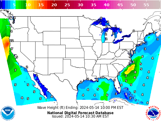
Surf's up:


WaveHeight6_conus.png


I just checked at home*and we're gettin' some gale force winds in gusts and lotsa rain, but that's it. :D

The weather gurus say by the time it hits the New England/New York area it may become a 'Perfect Storm'. :eek:

*We're up at our place in the NC mountains to see the leaves and visit family.
 
But wait, there's more!

From here (Note the "eek" faces are mine):
...National Oceanic and Atmospheric Administration forecaster Jim Cisco, who coined the nickname Frankenstorm, said: "We don't have many modern precedents for what the models are suggesting." :eek:

....Coastal areas from Florida to Maine will feel some effects, but the storm is expected to vent the worst of its fury on New Jersey and the New York City area, which could see around 5 inches of rain and gale-force winds close to 40 m.p.h. Eastern Ohio, southwestern Pennsylvania, western Virginia and the Shenandoah Mountains could get snow. And the storm will take its time leaving. The weather may not start clearing in the mid-Atlantic until Nov. 1 and 2 in the upper Northeast, Cisco said.

....It is likely to hit during a full moon :eek::eek::eek: when tides are near their highest, increasing the risk of coastal flooding. And because many trees still have their leaves, they are more likely to topple in the event of wind and snow, meaning there could be widespread power outages lasting to Election Day....

...Some have compared the tempest to the so-called Perfect Storm that struck off the coast of New England in 1991, but that one didn't hit as populated an area. Nor is this one like last year's Halloween storm, which was merely an early snowfall. "The Perfect Storm only did $200 million of damage, and I'm thinking a billion," Masters said. "Yeah, it will be worse."
 
Bearing in mind that Mother Nature sometimes has a few surprises for us over here, I think I might get the ole' rain coat and scarf out. Cold spells have a habit of travelling our way. . .
:(
 
Alas, it doesn't look like Florida is going to get off scot-free. Best get out the umbrella at least.

I don't mind the rain. As long as it's not freezing cold, I'm happy. Good luck to everyone.... :(

Kia kaha :rose:
 
http://forecast.weather.gov/product...D&format=CI&version=1&glossary=1&highlight=on

-- Changed Discussion --UPDATE...

WORDING IN HWO HAS BEEN STRENGTHENED BASED ON 00Z ECMWF AND 5 AM
NHC TRACK. IF THIS STORM DOES TRACK INTO NOVA/MD SIGNIFICANT FLDG IS PSBL
DURG THE 1ST PART OF NEXT WK.

PRVS DSCN...

THE LONG TERM FORECAST HINGES ON THE TRACK OF SANDY. PLEASE REFER
TO THE LATEST NHC ADVISORIES FOR MORE DETAILS. LATEST LONG TERM
FORECAST IS BASED ON THE LATEST TRACK.

WE ARE STILL SEVERAL DAYS AWAY FROM SANDY REACHING THIS LATITUDE...
AND THERE REMAINS GREAT UNCERTAINTY IN EXACTLY WHAT IS GOING TO
OCCUR. BY MON 18Z GFS AND ECM ARE ALMOST 375 MILES APART ON THE
LOCATION OF THE CENTER OF THE STORM. AT THIS TIME OFFICIAL HPC
FCST TRACK HAS THE CENTER OF THE STORM APPROX 270 MILES EAST OF
ORF MON EVE...AND INTO SERN PA TUE EVE. IN SPITE OF WHAT I`VE
WRITTEN DO NOT FOCUS SOLELY ON THE FORECAST CENTER OF SANDY. THERE
WL LKLY BE CHGS TO THIS TRACK IN THE COMING DAYS...AND W/ THAT
IMPACTS TO THE MID ATLC.

FORECAST FOR MONDAY/TUESDAY REFLECTS HIGHER POPS/CHANCES OF
PRECIPITATION IN ADDITION TO HIGHER WINDS. WHILE THE DETAILS ARE
UNCERTAIN...THERE IS THE RISK FOR HEAVY RAINFALL AND STRONG AND
POTENTIALLY DAMAGING WINDS EARLY NEXT WEEK AS SANDY OR THE
REMNANTS OF SANDY INTERACT WITH AN UPPER TROUGH AND IMPACT THE
CWA.

IF COLDER AIR MOVES INTO THE CWA TUE/WED PRECIPITATION COULD WIND
UP AS SOME SNOW ACROSS THE POTOMAC HIGHLANDS/HIGHER ELEVATIONS.
26/00Z ECM DOES NOT SUPPORT THIS IDEA...BUT FOR TIME BEING THE CHC
WL RMN IN THE GRIDS.

DURING MID-WEEK...WILL TREND THE FORECAST FOR LOWER POPS PER HPC
WEDNESDAY INTO THURSDAY WITH THE UPPER TROUGH/SANDY REMNANTS
SHIFTING FURTHER NORTH OF THE AREA.
-- End Changed Discussion --
 
Well... Looks like I will be right in the middle of everything...

My father is particularly worried about the trees around our house since the one fell over last year.
 
My father is particularly worried about the trees around our house since the one fell over last year.

And, I heard it pointed out on the TV last night, that, since the leaves haven't come off the trees yet, a winter storm like this just now is going to bring more trees down than usual.

One of the southernpost projected paths for this storm has it doing a loop around my house.
 
Well... Looks like I will be right in the middle of everything...

My father is particularly worried about the trees around our house since the one fell over last year.

My parents, in South Jersey and close to the shore but not on the shore, are not looking forward to a repeat of this summer's derecho and its aftermath. So here's hoping that doesn't happen.
 
Y'all are all welcome to come down here to Alabama till it blows over. Course down here we get to play with the tornadoes. Had one come through here in January. Picked a house up about three hundred feet from mine and drop it ten feet from its foundation.

About four in the morning. Nice way to be woke up.

Luckily I just had four trees come down is all. About a thirty foot tall maple and a pecan tree, a twenty five foot Magnolia and a big forty foot tall pine. Only one hit the house.

Totally destroyed a couple of subdivisions not far away.

We don't really get to do the snow thing down here all that often. Had a twenty inch snow storm hit one night. Shut the whole city down for a week.

Well other than it getting a bit cool, highs in the 60s lows in the 40s, we got good weather coming up. So Y'all come.

Hell I just finished building a Hotel near here. We got plenty of room for people to come do the getting away from it all thing. Grin.

Hell we even got the biggest cast iron ass in the world.
http://www.ramonacreel.com/BlogEntry.asp?Entry=1462

Grin
M.S.Tarot
 
But wait! There's even more....

On its current projected track, government forecasters said Sandy could make landfall early next week anywhere between Virginia, Maryland or Delaware up through New York or southern New England. In New York City, the global financial hub, officials were considering closing down mass transit before the storm hits....

...Much of Florida's northeast coast was under a tropical storm warning on Friday, and storm watches extended up the coast through North Carolina. Winds and rains generated by Sandy were being felt across much of Florida, with schools closed and air travel snarled in many areas.
See, Florida folk! I told you to the get the raincoats out.

I guess on the positive, we won't be hearing as much about polls or elections as news of this storm takes precedence. And those on the East Coast will be free of political commercials thanks to black-outs..... ("Always look on the bright side of life....")
 
-- Changed Discussion --

HIGH PRESSURE WAS LOCATED ALONG THE NEW ENGLAND COAST THIS
AFTERNOON...WHILE A COLD FRONT WAS MOVING EASTWARD ACROSS THE OHIO
VALLEY. EASTERLY FLOW AROUND HIGH PRESSURE HAS ALLOWED A STRATUS
DECK TO MAINTAIN ITSELF THROUGHOUT THE DAY EAST OF THE BLUE RIDGE
AND INTO THE FAR NORTHERN SHENANDOAH VALLEY. MEANWHILE..THE SUN HAS
BEEN SHINING ACROSS THE CENTRAL SHENANDOAH VALLEY AND POTOMAC
HIGHLANDS WITH SCATTERED CUMULUS.

WHILE CLOUD BASES WILL RISE A LITTLE THROUGH AFTERNOON...CLOUDS WILL
HANG TOUGH EAST OF THE BLUE RIDGE FOR A MOSTLY CLOUDY REST OF THE
DAY...AND EXPECT CEILINGS TO LOWER AGAIN THIS EVENING AS THE PATTERN
REMAIN VIRTUALLY THE SAME TONIGHT WITH EAST/NORTHEAST LOW LEVEL
FLOW. THERE MAY BE PATCHES OF FOG AND DRIZZLE EAST OF THE BLUE RIDGE
AS WELL. THE COLD FRONT WILL MOVE TOWARD THE APPALACHIANS..BRINGING
A CHANCE OF SHOWERS TO THE POTOMAC HIGHLANDS.

ANY DRIZZLE AND FOG TO START SATURDAY SHOULD DISSIPATE BY
MID-MORNING BUT EXPECT CLOUDY SKIES THROUGH THE DAY. THE COLD FRONT
WILL SLOW DOWN AS IT MAKES IT TO THE POTOMAC HIGHLANDS ON SATURDAY.
CHANCE OF SHOWERS WILL PRIMARILY BE RELEGATED TO THE POTOMAC
HIGHLANDS NEAR THE FRONTAL BOUNDARY...AND ALSO INTO LOWER SOUTHERN
MARYLAND AS A MOIST FEED WELL IN ADVANCE OF HURRICANE SANDY MAY
START TO BRING A FEW SHOWERS. PLEASE REFER TO THE LATEST NHC
ADVISORIES REGARDING SANDY.

-- End Changed Discussion --


It is a VERY unusual storm track. It'll be interesting to see if Sandy follows the script. Overnight, it appears that the projected landfall has been moved a bit north.


084458W_sm.gif


We are DEFINITELY feeling winds and such down here. Yesterday was especially windy. We were outside for a good portion of the day, and felt wind that was so fierce it nearly knocked my daughter off her feet. It's been whistling eerily through the open hallways of the apartment complexes for about 24 hours now. There was an interesting double rainbow that appeared yesterday afternoon/early evening as black clouds rolled in. I have not seen black clouds down here. Usually when it rains it just rains, sunshine and all, or the day starts off a little overcast and just stays that way. But these black clouds rolled in, and quickly continued on, with one random drizzle that last three minutes. I guess that was like a quick wave before hurrying on up to NJ and NY
 
Relatives from the coast are beginning to make reservations at my house (in the foothills of the Blue Ridge). Reminds me of the year they did that and the hurricane hit here rather than the coast.
 
Back
Top