voluptuary_manque
Literotica Guru
- Joined
- Sep 5, 2007
- Posts
- 30,841
There're a lot of people who would be very appreciative if Katia moved north . . .
Follow along with the video below to see how to install our site as a web app on your home screen.
Note: This feature may not be available in some browsers.
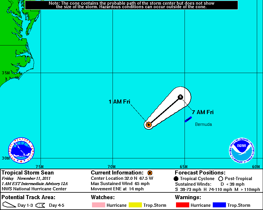
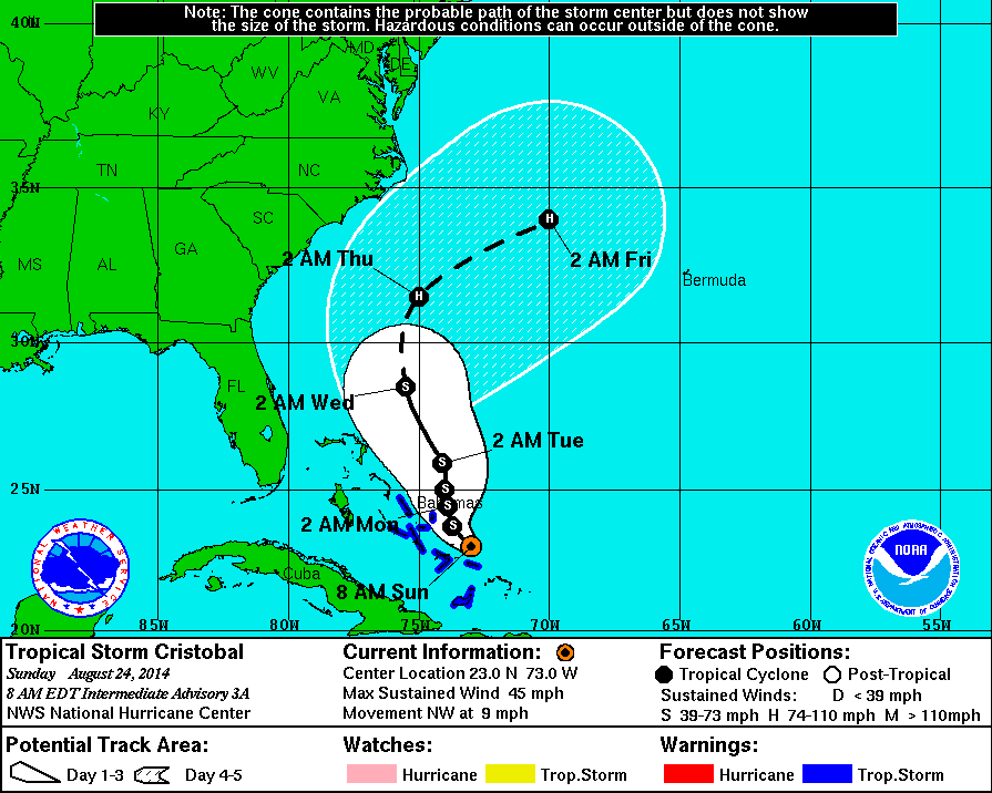
Resident as I was on the island of Bermuda when Tropical Storm Sean passed by at a distance of 80 miles, I can attest to the 45-55 mile per hour sustained winds and the 65 mph gusts that lashed the island for several days.
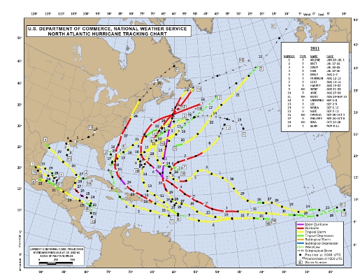
The Atlantic hurricane season spawned 19 storms, including Irene, which struck the East Coast in August leaving destruction from North Carolina to Vermont, a National Oceanic and Atmospheric Administration statement said.
The peak-storm period, which ends Nov. 30, ties 2010, 1995 and 1887 as the third-most-active one since 1851, according the statement. The average season produces 11 storms with winds of at least 39 miles (63 kilometers) per hour.
Hurricanes inflicted $153.7 billion in insured U.S. losses from 1991 to 2010, adjusted for inflation, accounting for 44 percent of all catastrophic losses in the period, according to the Insurance Information Institute in New York. Hurricane Irene, which struck in August, caused an estimated $7.2 billion in damage and killed 55 people in the Caribbean and 14 U.S. states, according to Weather Underground Inc.
In the U.S., New Jersey was hit the hardest with $915 million in insured losses, according to the insurance institute.
Irene became the first hurricane to strike the U.S. since Ike came ashore near Galveston, Texas, in 2008, NOAA said.
***
Hurricane Irene
“Irene broke the ‘hurricane amnesia’ that can develop when so much time lapses between landfalling storms,” Hayes said.
It has been six years since a major hurricane, with winds of at least 111 mph, has struck the U.S., the longest stretch on record. Wilma, in 2005, was the last.
Seven hurricanes with winds of at least 74 mph formed this year and three of them achieved major status.
***
This year’s storm total exceeded Colorado State University’s pre-season prediction of 16 named storms. It fell short of the institution’s forecast that nine of those systems would become hurricanes and five would be major hurricanes.
It also exceeded NOAA’s May forecast that called for 12 to 18 storms to form. In August, NOAA upgraded its prediction to 14 to 19 storms, with 10 becoming hurricanes and three to five achieving major status.
http://www.bloomberg.com/news/2011-...s-19-storms-in-third-most-active-year-1-.html

An El Niño may form in the Pacific Ocean within six months, potentially crimping the number of Atlantic hurricanes while bringing rain to the drought-stricken U.S. South and drier weather in Asia.
An El Nño watch was issued by the U.S. Climate Prediction Center in Camp Springs, Maryland, today because “there is a 50 percent chance” that the central Pacific will warm before the end of the year.
The formation of an El Niño, a warming of the Pacific, can have major impact on U.S. weather and on energy and agriculture markets. The most immediate would be on the Atlantic hurricane season, which can produce threats to orange crops in Florida, the second-largest producer behind Brazil, and to energy production in the Gulf of Mexico.
El Niño may also bring more storminess to the U.S. during the winter and cooler weather in the South, said Matt Rogers, president of Commodity Weather Group LLC in Bethesda, Maryland.
Several preseason hurricane forecasts, including those by Colorado State University and the National Oceanic and Atmospheric Administration, estimated there would be fewer storms this year than last, based on predictions that an El Nino would form.
El Nino enhances Atlantic Ocean wind shear, which is a change in speed or direction of winds at different levels in the atmosphere. The winds tear at the structure of growing tropical systems, preventing them from organizing or strengthening.
Drier Asia
The area from Northern Australia through Indonesia tends to be drier than normal during El Nino periods, according to the U.S. Pacific Marine Environmental Laboratory in Seattle. Less rain also falls during the Indian monsoon, said Jeff Masters, co-founder of Weather Underground Inc. in Ann Arbor, Michigan.
In the U.S., Southern states get more rain during December to February in El Nino years, according to the marine lab.
Earlier this week, the Australian Bureau of Meteorology also predicted an El Nino would form in the Pacific, citing seven forecast models.
“Ocean temperatures below the surface are currently warmer than average in the central and western Pacific,” the bureau said, adding that the eastern Pacific is slowly warming. “The tropical Pacific Ocean is likely to warm further.”
http://www.bloomberg.com/news/2012-...no-watch-that-may-affect-atlantic-storms.html
SUMMARY OF 400 AM CDT...0900 UTC...INFORMATION
LOCATION...28.6N 85.8W ABOUT 90 MI...145 KM SSW OF APALACHICOLA FLORIDA MAXIMUM SUSTAINED WINDS...50 MPH...85 KM/H
STORM SURGE...THE COMBINATION OF A STORM SURGE AND THE TIDE WILL
CAUSE NORMALLY DRY AREAS NEAR THE COAST TO BE FLOODED BY RISING
WATERS. THE WATER COULD REACH THE FOLLOWING DEPTHS ABOVE GROUND AT THE TIMES OF HIGH TIDE OVER THE NEXT FEW DAYS...
APALACHEE BAY TO WACCASASSA BAY...4 TO 6 FT
FLORIDA WEST COAST SOUTH OF WACCASASSA BAY...2 TO 4 FT
ALABAMA-FLORDA BORDER EASTWARD TO APALACHEE BAY...2 TO 4 FT
SOUTHEASTERN LOUISIANA TO ALABAMA-FLORIDA BORDER...1 TO 3 FT


Heck. It doesn't even look like a good day to be outside in Bermuda or the SE coast.